Drivers in North Jersey have a love-hate relationship with the Pulaski Skyway. It's a toll-free alternative to the Turnpike's Newark Bay Extension if you want to get to the Holland Tunnel, but it's also a narrow, claustrophobic and often clogged artery that lacks anyplace for a disabled vehicle to pull over. Anybody who uses the Pulaski on a regular basis will tell you that the road is incredibly outdated, dangerous, way too small for the volume of traffic that uses it, you name it. And there are people who say its black-painted cantilevered bridges add to the ugliness of one of the most industrialized parts of the state.
Say what you want about it, but when it opened in 1932 as the Route 1 extension, it was lauded as the Most Beautiful Steel Structure by the American Institute of Steel Construction. The WPA Guide to New Jersey deemed it "outstanding among state highways" and a "pioneer achievement in ... handling through traffic in one of the most congested areas of the world," especially given the challenges of road building in the marshy terrain. Its cantilevered bridges cross both the Passaic and Hackensack Rivers at a clearance of 135 feet to accommodate War Department requirements; presumably for the safe passage of naval vessels. I can't imagine a warship traversing that far up either river today, but I guess they weren't leaving anything to chance.
The highway was a huge timesaver for motorists attempting to travel between Newark and New York, who had previously been forced to traverse the marshlands in a two-and-a-half hour odyssey of local roads and drawbridges. The opening of the Skyway reduced that trip to an estimated 15 minutes. Engineers promoted its virtues in terms of vehicle miles saved, estimating that the availability of the 3.5 mile long elevated road would save car drivers over 57 million miles of driving per year.
With all of those advantages, why has the Pulaski become such a target of fear and avoidance? According to the State Department of Transportation, its design represents "one of the first attempts to create a coherent elevated highway network," but it seems the attempt wasn't all that successful. Believe it or not, the Skyway was designed by railroad engineers who knew a lot about building train viaducts but not much about roads, and it shows. The lanes are a slim 11 feet across, and where there's now a center divider was originally a breakdown lane that both directions of traffic used as a de-facto passing lane, resulting in many accidents.
And while the Pulaski was envisioned as an expressway between its two terminal cities, powerful Jersey City Mayor Frank Hague insisted that entrance lanes be added midway, in a part of the city he felt was ripe for development. He may have been correct, but in the meantime, he demanded the creation of some pretty scary, steep ramps leading directly into heavy traffic. (Hague was also locked in a bitter battle with union leadership that resulted in a virtual labor war and the death of one worker, but that's a story for another time.)
First called the Diagonal Highway, the causeway was named for Casimir Pulaski shortly after its dedication. A Polish nobleman who fought in the American Revolution, he's considered by some to be the father of the U.S. cavalry. It's said that he was a dashing figure, both brave and aggressive in battle, traits that would serve a Skyway traveler well. If you're feeling particularly brave or foolhardy, the Pulaski also offers slim pedestrian walkways on its outer edges, where shoulders might have been a wiser addition. (Anybody up for a nice Sunday stroll over the meadows?)
The State Department of Transportation recently announced an eight-year, $1 billion project to rehabilitate the Skyway, with some of the work already underway. The biggest hassle will be the deck replacement that will require the closing of Jersey City-bound lanes next year. Ramps will also be updated, seismic structural repairs done, and the whole shebang will get a coat of paint at the end. The DOT estimates that the fixes will add another 75 years to the life of the road.
Some might wonder why they don't just take the whole thing down and build a new highway, but between demolition and construction, the cost would far exceed the rehab budget. As it is, engineers and construction crews will need to honor the original design intent, as the Pulaski is listed on both the State and National Historic Registers. And given the amount of development that's grown around it in the past 80 years, any major structural changes would disrupt a lot more than local traffic. Love it or hate it, the Pulaski Skyway is with us to stay.
Showing posts with label notable bridge. Show all posts
Showing posts with label notable bridge. Show all posts
Friday, February 8, 2013
Tuesday, January 15, 2013
On a road to nowhere in Manahawkin
We had a long day of ups and downs in the greater Cape May area on Saturday, looking for additions to our respective year lists and visiting the reported spots to see the more remarkable rarities that had been reported to be in the area.
As a quick update:
A confession: whenever Ivan mentions owling, I do a mental eyeroll, especially in pine forests where they might be tucked in broad daylight. Don't get me wrong. I love owls. In fact, our first joint birding experience was a January visit to Wallkill WMA to visit the short-eared owls. He got one in the viewing scope within a few minutes, and it accommodatingly turned to face us just as I was getting my look. Since then, it's been a lot harder to tease them out, but in Ivan's defense, owls of any ilk do their best not to be seen. Finding them takes a certain amount of luck, regardless of how advanced your birding skills are.
This time around, when I started my usual jovial owl rant, Ivan simply said, "You'll like this place. It's the road to nowhere." Say no more. Let's check it out.
We got to Route 72 as twilight was descending. A few turns brought us away from the state highway hubbub and into marsh territory. One more right turn and we were on Stafford Avenue, a lightly-traveled road occasionally marked with a pothole. "This is better than I remembered it," Ivan told me, explaining that the road is rarely maintained and can get heavily rutted and uneven a mile or so in, when it turns to hard-packed sand and dirt.
The road goes first through a forest, adding a little spookiness to the trip, but then the horizon widens to accommodate marshgrass, with no trees to obstruct the view for acres. Harriers ordinarily would have been scouting for their last meals of the day, but we saw nothing in flight. Still, the terrain was incredibly cool, as was the feeling that absolutely nobody was within shouting distance. The only real sign of human progress was the utility poles on the side of the road, though four or five of them were tilted dangerously enough to take the whole system down into the brackish water with a good gust.
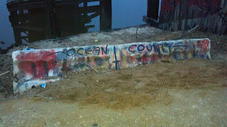
Then we got to the really cool part. The road ramped up a little before being blocked by a graffiti-laden Jersey barrier. Whoa. The car had barely stopped before I jumped out and walked up to the barrier to find remnants of an old wood bridge, its near end gone, making it impossible to walk across. It doesn't matter, anyway, as there's no road on the other side.
 "Behold!" Ivan exclaimed as he stepped out of the car. "Nowhere!" He had that right. Marsh stretched out almost as far as the eye could see, and it was so quiet, well, so quiet that any of the usual analogies about quiet were useless. That, my friends, is Manahawkin Wildlife Management Area at dusk in January.
 How was I not aware of this place? I pride myself on knowing these spots, and from what I can recall, our better-known friends who cover the odder parts of the state haven't featured this Road to Nowhere. It seems that perhaps it's a secret kept by sportsmen (the state DEP maps list the area as the Manahawkin Hunting and Fishing Grounds) and birders, with the occasional spray paint-wielding local teen for good measure. I could see where the hunters and fishing enthusiasts would value the area; the marsh was sparsely crossed by old mosquito-control channels they could use to get to a blind or favorite spot.
 Gazing across the marsh from one of its few (maybe only) high spots, I was again reminded of the Meadowlands -- the rickety old abandoned bridges you can see as your train rumbles along to Newark or New York, the ditches dug in the futile hopes of keeping the skeeters at bay, the wisdom of letting a certain amount of marsh just be and be natural.
As for the owls, well, they were keeping to themselves during our visit. We saw none at all before daylight finally surrendered to darkness, though Ivan thought he might have heard a short-ear bark in the distance (some say they sound like terriers). Perhaps next time.
As a quick update:
- A report of a king eider hen near a jetty in Cape May Point delivered a common eider for us. (That beach spot also yielded the rare bare-rumped jaybird, but that's another story.)
- A very yellow western tanager revealed himself after a very brief wait on a busy street corner in Cape May Court House.
- And... after what would have been deemed a wild goose chase in other circumstances, we caught a glimpse of a crested caracara (you might remember how rare these are in New Jersey, after our story of seeing one in West Windsor last year.)
A confession: whenever Ivan mentions owling, I do a mental eyeroll, especially in pine forests where they might be tucked in broad daylight. Don't get me wrong. I love owls. In fact, our first joint birding experience was a January visit to Wallkill WMA to visit the short-eared owls. He got one in the viewing scope within a few minutes, and it accommodatingly turned to face us just as I was getting my look. Since then, it's been a lot harder to tease them out, but in Ivan's defense, owls of any ilk do their best not to be seen. Finding them takes a certain amount of luck, regardless of how advanced your birding skills are.
This time around, when I started my usual jovial owl rant, Ivan simply said, "You'll like this place. It's the road to nowhere." Say no more. Let's check it out.
We got to Route 72 as twilight was descending. A few turns brought us away from the state highway hubbub and into marsh territory. One more right turn and we were on Stafford Avenue, a lightly-traveled road occasionally marked with a pothole. "This is better than I remembered it," Ivan told me, explaining that the road is rarely maintained and can get heavily rutted and uneven a mile or so in, when it turns to hard-packed sand and dirt.
The road goes first through a forest, adding a little spookiness to the trip, but then the horizon widens to accommodate marshgrass, with no trees to obstruct the view for acres. Harriers ordinarily would have been scouting for their last meals of the day, but we saw nothing in flight. Still, the terrain was incredibly cool, as was the feeling that absolutely nobody was within shouting distance. The only real sign of human progress was the utility poles on the side of the road, though four or five of them were tilted dangerously enough to take the whole system down into the brackish water with a good gust.
 |
| The bridge to nowhere. |
 "Behold!" Ivan exclaimed as he stepped out of the car. "Nowhere!" He had that right. Marsh stretched out almost as far as the eye could see, and it was so quiet, well, so quiet that any of the usual analogies about quiet were useless. That, my friends, is Manahawkin Wildlife Management Area at dusk in January.
 How was I not aware of this place? I pride myself on knowing these spots, and from what I can recall, our better-known friends who cover the odder parts of the state haven't featured this Road to Nowhere. It seems that perhaps it's a secret kept by sportsmen (the state DEP maps list the area as the Manahawkin Hunting and Fishing Grounds) and birders, with the occasional spray paint-wielding local teen for good measure. I could see where the hunters and fishing enthusiasts would value the area; the marsh was sparsely crossed by old mosquito-control channels they could use to get to a blind or favorite spot.
  Gazing across the marsh from one of its few (maybe only) high spots, I was again reminded of the Meadowlands -- the rickety old abandoned bridges you can see as your train rumbles along to Newark or New York, the ditches dug in the futile hopes of keeping the skeeters at bay, the wisdom of letting a certain amount of marsh just be and be natural.
As for the owls, well, they were keeping to themselves during our visit. We saw none at all before daylight finally surrendered to darkness, though Ivan thought he might have heard a short-ear bark in the distance (some say they sound like terriers). Perhaps next time.
Tuesday, January 3, 2012
No EZPass on the Dingmans Ferry Bridge
I was one of the EZPass holdouts until October, when I got this while using a staffed tollbooth:

Ridiculous as it is not to be able to use paper money on the Parkway, I finally relented and picked up a transponder. I still keep pocket change in the car, though, as there are places in the region where EZPass has yet to extend its tentacled detectors.
Take, for example, the Dingmans Ferry bridge, which links Layton, Sussex County, to Pennsylvania in the Delaware Water Gap. This privately owned river crossing is decidedly low tech, with not even an automated collection basket. One toll collector stands on the line between the two lanes at the Pennsy side, taking tolls from both directions, protected by an awning. The north side of the awning is held up by a little toll house, while the south side is essentially a trellis with signs posted for the next Kiwanis pancake breakfast or Girl Scout fundraiser. It's been this way pretty much since the bridge was constructed, the fourth in a series that runs back to 1835.
Starting a century before that, Andrew Dingman ran a successful ferry service between Layton and Pike County, PA, until one of his descendants opened the first of the bridges. Seemingly, neither that bridge nor the two that succeeded it were constructed to withstand the elements brought by the Delaware and the occasional flood. Today's bridge was built in 1900 of sturdy steel and is closed for inspection for a few days every year to assure its safety. So far, it's held up in four major floods, and one would surmise that with that kind of record, it'll be around for a long time.
Back to the toll taking, I wonder what do they do overnight? Is there an evening toll collector? What kind of traffic does he or she see? And how do they manage in foul weather?
According to the company website, those traveling to church or funerals don't have to pay the toll, but I do wonder, though, if the Dingmans Choice and Delaware Bridge Company people will eventually succumb to EZPass. Perhaps the toll taker will stand in his usual spot and hold a transponder reader to essentially bar-scan people across the bridge.
Monday, October 10, 2011
Exploring the industrial past: the Roebling Museum
I'll make it to Burlington someday. I swear.
Ever since our visit to the provincial capital of East Jersey, Perth Amboy, I've wanted to see its West Jersey counterpart, Burlington City. For one reason or another (Turnpike issues, birding imperatives elsewhere), we just haven't made it, and I figured I'd take one of our recent beautiful weather days to make the drive while Ivan was occupied with a client.
Then I saw the brown sign for Roebling. You know what those brown signs mean: there's something interesting there. Follow that sign, leave Route 130 and cross the railroad tracks, and you land at the site of the former Roebling steel mill. It's an interesting vision: on one side, you see a fenced-in expanse of grass with what looks like two parallel monorail tracks high above ground, and some industrial equipment beneath. On the other side, you see construction trailers and a large expanse of disturbed earth. In the middle, there's a parking lot for the Roebling Museum, punctuated by an old green wooden building. The museum itself is at the top of an incline, as if to tower ever so slightly above the field below.
There's a good reason for that, I discovered. The museum building was originally the Roebling factory gatehouse, holding several different functions including a first aid station and a three-cell jail. I was welcomed in by two very friendly docents who were more than happy to guide me through exhibits outlining the Roebling family, evolution of their company and the factory, and the adjoining town.
You might recall that earlier this year, Ivan and I visited one of John Roebling's early bridges, the Delaware Aqueduct spanning the Delaware River between New York and Pennsylvania. Town residents are justifiably proud of that span as well as the several more famous bridges containing Roebling wire: the George Washington, Manhattan, Verrazano Narrows and Golden Gate, among others. My guide pointed out that as an engineer, John Roebling designed and built a then-unique bridge over the Niagara River which conveyed trains on a top deck and horses and carriages on an underdeck. Had it not been rendered obsolete by changes in railroad technology, it might still be in use today.
 Bridges, however, were only one use of Roebling products. Both the Wright Brothers airplane and the Spirit of St. Louis contained Roebling wire. Otis elevators were suspended by Roebling steel cables specifically designed to handle the unique stresses of pulleys and loads of varying weights. Remember the Slinky? Yup -- made from Roebling wire. Essentially, if you needed extruded steel, Roebling could and often did supply it, in gauges down to the width of a human hair.
I'm getting ahead of myself, though. To supply the wire rope for the bridges, the Roebling family established a steel mill-factory complex in Trenton, based on the recommendation of a friend who lived nearby. Soon, however, they'd expanded beyond the capacity of the property and needed another location. The village of Kinkora, about ten miles south of Trenton, was just the place -- close to the Pennsylvania Railroad and the along the shores of the Delaware River. The company bought three farms there in 1905 and got to work.
Along with a state-of-the-art manufacturing facility, the Roeblings built a company town to house the substantial workforce needed to operate the factory. I'll get into that in our next installment, but I'll say that the museum exhibit gives a great view into who worked at the plant and life in the village during the factory's heyday. You can also pick up a self-guided walking tour if you'd like to get a closer view of present-day Roebling.
 The family sold the mill to Colorado Fuel and Iron in 1952, and it stayed in operation until 1974. Now only a few small buildings are still standing. Declared a Superfund site in 1983, most of the area has been remediated, though the Army Corps of Engineers is still on site, explaining the construction trailers I saw.
In all, the Roebling Museum tells an interesting story of American industrialism and its impact on both society and the people who worked there. I was particularly impressed by how well the information is presented, both in the exhibits and by the docent. They also host a series of special events; the next will be a lecture and tour of the town on October 15.
Oh, and when you go, be sure to check out the massive flagpole next to the guardhouse. You can't miss it: it's the third highest flagpole east of the Mississippi.
Monday, September 26, 2011
Who's good and kind and has bridges named after them?
Cross the Raritan River on Route 1 northbound, and you'll see a sign commemorating the Morris Goodkind Bridge you're traveling atop.
Cross the Raritan River on Route 1 southbound, and you'll see a sign commemorating the Donald Goodkind Bridge you're traveling atop.
I've been taking this route occasionally for my entire adult life, and it's only recently that I discovered the difference. Sure, I'd noticed that the two directions are carried on different spans, with the southbound bridge being several years newer than the northbound, but I never gave the name much thought. I knew the Morris Goodkind name, but I guess I assumed it covered both directions, and I assumed he was a notable New Jerseyan from colonial times. Discovering the Donald connection got me curious. I don't know of many colonial Donalds.
So who are these Goodkind guys, and why do they get bridges named after them? The answer is quite simple, actually: they were both engineers with the New Jersey Department of Transportation and responsible for the design of the bridges that now bear their names.
The older bridge, built in 1929, is much more graceful: concrete with arches beneath and commemorative plaques embedded at either end. I've never been able to read them because they're against the left-most lane and impossible to get to with your life intact; in more recent years they've also been sprayed with graffiti. There's a war memorial at the southern end, largely unreadable at highway speed. Originally called College Bridge, the span was named after the elder Goodkind in 1969, just one of his many accolades. He'd won a medal for excellence in bridge design from the American Society of Civil Engineers for the bridge's design and eventually became chief bridge engineer for the state highway department. The Pulaski Skyway is just one of the spans built under his leadership. Interestingly, he'd begun his career in subway design in New York City.
According to the Encyclopedia of New Jersey, Morris believed that bridges were monuments to structural elegance and that unless a bridge was beautiful, the engineer had not given all that was expected of him. It's a shame that his son didn't (or perhaps couldn't) design the newer bridge consistent with that goal. A garden-variety highway bridge of steel and concrete, the southbound span was built in 1974 and named after Donald in 2004. Maybe engineering standards at the time favored that kind of design, or maybe it was more cost effective, but wow ... not really all that impressive-looking. The body of his work, however, warrants recognition. Like his father, Donald also made notable contributions to the state's roads and engineering discipline. He was also a trustee of the New Jersey Institute of Technology and co-founder of the state Consulting Engineers Council.
You have to admit, there's a nice little symmetry to the father-son bridges. They show the tenor of their times, and they certainly get the job done.
Thursday, June 30, 2011
Hidden New Jersey trivia: the Outerbridge Crossing
Yesterday was the anniversary of the opening of the Outerbridge Crossing, the span that connects Perth Amboy, New Jersey with Staten Island. Along with its sister to the north, the Goethals Bridge, it was constructed by the Port of New York Authority (now the Port Authority of New York and New Jersey) and opened on June 29, 1928.
Many travelers know of the Outerbridge but if you asked them the origin of the name, it's highly doubtful they'd come close to the right answer. While it's the southernmost crossing connecting New Jersey with a portion of New York, it's not the Outerbridge because it's the outermost roadway among them all. Rather, it's named for Eugenius Outerbridge, the first chairman of the Port Authority. Obviously they weren't going to call it the Outerbridge Bridge. Well, I guess they could have, but it would have sounded pretty silly.
Outerbridge himself was a pretty interesting man, having led the Port Authority as it conceived a comprehensive development plan for the harbor. Born in Philadelphia, he spent much of his career in importing/exporting. He also ran a business that made fiberboard for vehicle roofs, eventually manufacturing a product called Homasote, which used recycled materials. Plus his sister Mary was the creator of American lawn tennis. No word on whether she ever played on fiberboard.
Now... a question for you! From what or whom does the Holland Tunnel get its name?
Subscribe to:
Posts (Atom)