Wednesday, February 29, 2012

The real George Washington Bridge... at New Bridge Landing

Totally exhausted from a long work week (Ivan) and a persistent head cold (me), we eschewed the usual wandering around this weekend for a more targeted trip. We'd driven through River Edge a few weeks ago, reminding me of New Bridge Landing and the Steuben House. I'd worked nearby for a stretch, and the small park there had been one of my favorite places to eat lunch on nice days. Besides the aforementioned house, a few other colonial-era buildings had been moved to the site on the banks of the Hackensack River, but I'd never been inside any of them. That was reason enough to check it out.

I thought I knew the story here: the house was once owned by loyalists named Zabriskie, and after the war, it was given to Major General Baron von Steuben, Inspector General of the Continental Army. That's all correct, but this is much more than a colonial house site. If you're to believe the signage that's gone up since my lunching visits, New Bridge Landing is the site of the real George Washington Bridge.

Today, the Hackensack barely flows past the Steuben house, having been impounded a few miles upstream to feed the Oradell Reservoir. At the time of the Revolution, though, the old Hacky was deep enough to supply a gristmill on site, supplemented by a nearby pool to make up for the effects of the river's tides. A wooden bridge there was the southernmost point at which the river could be crossed by man-made span, and commercial traffic took full advantage of the opportunity. The land surrounding the river farther downstream was even marshier than it is today, making it nearly impossible to build useful roads. If the muck didn't get you, the mosquitoes would.

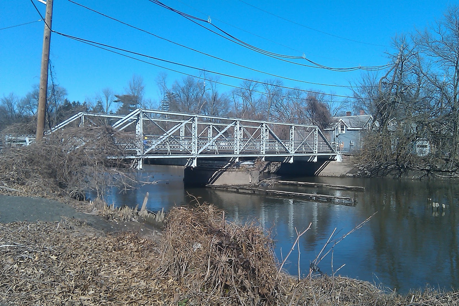
This steel swing bridge replaced the "Washington" bridge
in 1888 and is the oldest span of its type in New Jersey.
Knowing the local terrain meant the difference between survival and surrender for Washington's troops during some of the darkest days of the Revolutionary War. Cornwallis' British and Hessian troops crossed the Hudson in the early hours of November 20, 1776, with the goal of capturing Fort Lee (that's the actual fort, not the town we know today) and the nearly 1000 Continental soldiers garrisoned there. If the troops didn't move fast, they'd be trapped on the narrow peninsula between the Hudson and the Hackensack. And if the British got to New Bridge first, they'd not only be able to capture the Continentals, they'd have a strategic path to penetrate New Jersey and move westward into Pennsylvania without hindrance from the patriots.

Washington was already in the town of Hackensack and met his troops as they neared the crossing. Uncontested by the British, the men made it across the river, marched toward Hackensack and eventually made their way to Newark to recoup. It wasn't until the following day that Cornwallis' troops moved to capture the bridge, which they did successfully despite the efforts of the Continentals' rear guard.

Writer Thomas Paine was an eyewitness to the crossing and related the news in his tract The American Crisis, published about a month later. The decisive battles of Trenton and Princeton were yet to occur, and Paine was pretty much an embedded reporter in current day parlance. His opening words, "These are the times that try mens' souls" were written in New Jersey and still stir passion in the hearts of American patriots today.

Things are a lot more peaceful at New Bridge Landing now. Even though Route 4 and busy Hackensack Avenue aren't far away, you can conjure your own little calm by standing on the bridge and looking south. When we were there, the tide was out and Ivan noted that the mudflats would be great for shorebirds. We didn't see too much avian action but heard quite a bit of spring song in the air. A passive recreation park and greenway on the eastern side of the bridge offers even more opportunity to relax and get back to nature, even with houses across the quiet street.

The Bergen County Historical Society manages the Steuben House but hasn't held regular hours there since the property was flooded during a nor'easter in 2007. Their website has an exhaustive history of the property, along with relevant text from Paine's work.


Monday, February 27, 2012

Voorhees, the final frontier....

Quick! Who was the first New Jerseyan in space? And who was the first state native to set foot on the moon? I'll give you two hints: they're not the same person, and they're honored somehow in Voorhees State Park.

A road marker brought Ivan and me to discover this previously unknown (at least to us) gem. You might have noticed one yourself on Route 78 or Route 22: a brown sign that enigmatically says "NJAA Observatory," with no other explanation. The traveler is left to wonder what NJAA is, and what they're observing. New Jersey Automobile Association, watching traffic? New Jersey Alcoholics Anonymous, keeping members on the path to sobriety? This time we decided to take the detour and find out.

A little blurry -- perhaps the state's largest publicly-available
telescope would have put it into sharper focus.
Another sign on County Route 513 brings you into Voorhees State Park, through deep woods and to higher elevation. Surprisingly, Ivan didn't want to stop to do any birding, having had poor luck there in the past. We continued driving until we reached a sign stating "Paul Robinson Observatory/Home of the New Jersey Astronomical Assn."

Why hadn't we considered an actual space observatory as a possibility? It makes some sense: altitude, distance from the light pollution of heavily-populated areas, and surrounding land that likely will never be developed. The skies aren't as reliably clear as those at Mauna Kea in Hawaii, but then the average observer doesn't have to worry about sudden bouts of hypoxia, either.

The observatory was conceived in 1965 by a group of seven men who wanted to share the science of astronomy with others. Led by Paul Robinson, they eventually were able to lease land from the state, build the facility and obtain a 26 inch diameter mirror telescope from Indiana University. The larger of two buildings is named for Montclair native Edwin "Buzz" Aldrin, who was the second human (and first New Jerseyan) to set foot on the moon. A smaller adjacent observatory building is named for Hackensack-born Wally Schirra, who was the fifth American (first New Jerseyan) in space and the first human to make three trips into space.

Unfortunately the place was closed when we stopped by -- they don't have winter hours until the last weekend of February, probably because the road wouldn't be that reliable after snow and ice storms. If you visit when they're not open, you can still check out the outdoor virtual solar system, which includes wayside signs describing each planet of our solar system, sited in proportion to their true spatial relationship to one another. We wondered if Pluto was still part of the exhibit, given its demotion from planet status, but decided it was unlikely anyone had ever walked out that far to see the sign, anyway.

The observatory is on our ever growing list of things to return to, once it's open again. Check out the NJAA website for operating days and hours, plus a full schedule of lectures and events.

Friday, February 24, 2012

Califo(r)n(ia), here we come!

If your mind plays with words the way mine does, you often wonder about the origins of terms and especially names. It was that with me and the quaint, mile-square town of Califon in Hunterdon County. Far be it from me to cast judgement on a name, and 'Califon' is a perfectly serviceable one, but it sounds too much like something else to be a name on its own merits.

Turns out that the original name wasn't Califon at all. It was California. Resident Jacob Neighbor had gone west to seek his fortune in the 1849 gold rush, and flush with success, he returned to build a couple of saw mills on the nearby South Branch of the Raritan River. Honoring the place where he'd made his fortune, he called the settlement "California."

So far, so good, but how does California become Califon? The official story is that the name change occurred when the train station painters couldn't get the entire name onto the sign. Another version states that the painters were too inebriated to get all of the letters painted.

Regardless of the origin of the name shortening, Califon proper is a delightful little Victorian-era enclave of just over 1000 residents. They're clearly proud of their little town and its history, with 170 structures on the National Register of Historic Places and a vintage trestle bridge crossing the river. At one time, the community hosted a variety of industries, including an iron and steel works, stone quarries and even a basket factory, but there's no visible industrial activity left. It's simply a quiet community with shops, parks, and a meandering river.

Tuesday, February 21, 2012

Highway history, made in Hunterdon County

You know Jersey barriers, right? Those concrete dividers in the middle of major highways? The ones that are designed to keep drivers from swerving into oncoming traffic?

I always assumed that they were invented by the folks who brought us the New Jersey Turnpike. Given how many innovations its designers contributed to highway engineering, it only seemed natural, so imagine my surprise when Ivan and I passed this historical marker on Route 173 in Hunterdon County.


The Encyclopedia of New Jersey tells us that the Jersey barrier was "developed ... to minimize the number of out-of-control trucks penetrating the median and eliminate the need for costly and dangerous steel guardrail median barrier maintenance in high-accident locations with narrow medians." Sounds like a problem for a major highway, right? Who'd have thought that the first place it would be installed would be cow country?

On second thought, it makes a lot of sense. I can see where western New Jersey would be a good test area, with lots of two-lane roads where opposing traffic could easily stray in darkness or bad weather, or drunkenness on the part of the driver. As the sign in Bethlehem Township infers, there were plenty of bad accidents right on 173 that likely could have been prevented with a partition separating traffic.

Further research reveals that the original 32-inch barrier was developed at Stevens Institute in Hoboken, under the direction of the state Department of Transportation. The Turnpike Authority later used that design and an Ontario variant to create a highly-reinforced model that effectively shunts errant semi trucks back into the proper lane of traffic.

The irony is that while we saw Jersey barriers all along Route 78 on our trip toward the historical marker, there are no barriers at all on 173. Instead, there's a turning lane in the center of the road, shared by both directions of traffic. It's kind of a shame there's not at least a little bit of the original barrier left in the road, sort of our own New Jersey version of the Berlin Wall. Wouldn't it be cool if there's a remnant of it being preserved somewhere?

Sunday, February 19, 2012

Good old-fashioned New Jersey mudslinging hits the major leagues

I don't care how balmy it gets over the winter. I believe that spring begins when pitchers and catchers report to major league training camps in February. That's happening this week, and it seems it won't be long till we can watch intrasquad play and preseason competition.

I don't know if this ball ever got the mud treatment,
but it's still pretty cool.
No matter where those games are played, they'll all have a little New Jersey in them. Or, more accurately, on the balls the players use. Before each and every major league game, umpires rub a special concoction of Garden State mud into the hides of several dozen baseballs to take the shine off the covering. Reportedly, this makes the ball easier to grip, so it's less likely that a pitcher will lose control and inadvertently hit a batter in the head. Following the beaning death of Cleveland Indians shortstop Ray Chapman in 1920, the urgency for finding a solution to this problem became more acute.

What is it about New Jersey mud that makes the difference? Why can't the umpires just use dirt from the infield of the park where the game is being played? In the early days of baseball, the umps did, in fact, often turn to ballpark dirt, shoe polish and even tobacco juice to effectively dull the ball's surface leather. Only problem was, these methods would either discolor or scratch the balls, making them unsuitable for game play.

After listening to an umpire's complaints on the topic, Philadelphia Athletics third base coach Lena Blackburn decided to find a solution. In the late 1930's, he came upon the perfect mud somewhere near Palmyra, allegedly on a tributary of the Delaware River. Using a proprietary method, he screened the mud and then cured it over the winter before distributing it for use. The pudding-like substance roughs up the balls sufficiently for gripping, without causing any real damage. By the 1950s, every major league team was using Blackburn's mud.

I'm just as curious about the origins of that mud as you probably are, but it's a closely-held secret. It's so secret, in fact, that only four men have known its location: Blackburn, his friend John Haas whom he willed the business to, Haas' son-in-law Burns Bintliff, and the current mud collector, Jim Bintliff. (You have to admit -- those are all really baseball-sounding names.) According to a CNN story, the next person to be admitted to the fraternity of baseball mud collectors may be a woman: Jim's daughter Rebecca, and no doubt she won't tell, either.

In a given year, the business doesn't make much money, but I'm sure it gives a heck of a lot of satisfaction. Imagine watching any major league game and knowing you helped make every pitch happen. That's a feeling you can't buy.

Friday, February 17, 2012

If you drive on a parkway and park on a driveway, what do you do on the state's shortest highway?

Since I was a kid, it's been on my bucket list to walk one of New Jersey's highways from end to end. I'd read Michael Aaron Rockland's accounts of hiking Route 1 and Route 22, and the idea, while a bit crazy, seemed like a good one. You can see a lot more at a walking pace than you ever could from a speeding car.

There are a lot of logistics to consider before you take on a highway walk. Where will you stay at the end of the day? Do you have someone pick you up, drive you home and then return you the next morning to the place where you left off, or do you find a motel? How much sustenance do you carry? And how do you deal with the lack of sidewalks? Traffic has gotten heavier and faster since Rockland made his treks in the late 70's, so perhaps his methods wouldn't suffice. Obviously, I need to select my walking highway very carefully.

I think I've found it: State Route 59. Lined with a sidewalk for its full length, its traffic is reasonable and I'm certain I could walk it in a single day. If I can't there's definitely something wrong: it's only 0.15 miles long.

Planned route for NJ 22.
Why in heck would the state build such a short highway? The simple answer is that it didn't mean to. Originally designated State Highway 22, the road was to stretch from the Pine Brook bridge in West Caldwell to Route 27 in Rahway. For some reason, plans never came to fruition, so we're left with a brief bit of road that passes under the Raritan Valley Line railroad bridge, as well as a classic concrete New Jersey highway bridge railing at the intersection of 59 and State Route 28 in Garwood.

If you stand next to that concrete bridge rail and look north, you stare straight at an old residential neighborhood. Maybe that was part of the issue -- the state would have had a heck of a time gaining the necessary property for the road, even with eminent domain.

Looking at the inscriptions on the end posts on the concrete bridge, you'd be forgiven for wondering if the road was intended to be a spur of or replacement for the highway we know today as US Route 22. Route 59 was, in fact, originally designated as State Route 22, even though US 22 already existed in New Jersey (however, in Union and Essex Counties, US 22 was known as State Highway 29, which doesn't intersect with current day State 29 in the Trenton/Lambertville area. Confused yet?). This and other thoroughfare perplexities necessitated highway renumberings in 1927 and again in 1953, when our little 0.15 mile of heaven was redesignated as 59. Nobody made the change on the bridge marker, though, so observant passers-by will no doubt have fun trying to figure out how much more convoluted 22 could possibly get.

One of these days, I'll hit the road and actually walk the length of 59. I'll park at the Walgreens at the southern end, carefully cross the driveway, walk under the railroad overpass and continue past the empty lot to the right until I reach the corner. I might even cross Route 28 to check out the concrete bridge and then head to the adjacent liquor store for a celebratory beverage. I won't want to drink it there, though: it'll be another road crossing and a little more than a tenth of a mile to get back to my car. That's not nearly enough time to get my blood alcohol content down to drive legally.

Tuesday, February 14, 2012

Oh, the humanity! Wandering around Lakehurst.

First it was the railroad hub for the Pinelands.

Then it became a popular resort.

Then it was the site of the nation's first international airport and the place where the growth of the passenger airship industry came to a fiery halt.

And now its population has soared, thanks to the host of retirement communities built there over the past 30 years.

Yup, I'm talking about Lakehurst, Ocean County. On one of our rare non-bird-related jaunts, Ivan and I made our way down the Parkway to Route 70, drawn by the lure of another type of flying object. We hadn't registered in advance for a tour at the Naval Air Engineering Station, but I was confident we'd uncover something worthwhile. Any small town that gained international notoriety for a disaster had to have plenty of interesting stuff. Plus, it's in the Pinelands, where the unusual is commonplace for explorers.

Leaving the highway and heading to the compact downtown, we saw that the locals take pride in their connection to the history of the airship. Whether you call them blimps or dirigibles or something else, they're represented in a lot of signage and outdoor artwork around town. Awnings on borough hall proclaim Lakehurst to be the Airship Capital of the World (take that, Friedrichshafen!), and even the local laundromat sports a large painting of a Buddhist-themed airship. Om, the humanity?

That's the south side of the highway. The Naval Air Engineering Station is down a road to the north, obscured by the region's signature pines. Signs warn passers-by about security measures and low-flying aircraft, reminding us that even though it's a historic landmark, the airfield is still an active military base. It's difficult to get a clean photo of the massive airship hangar from the road or a nearby housing development, though the building towers above the scrub pines in the foreground. Disappointing, yes, but we had other destinations to check out.

First, however, it was time for lunch. Regular readers know that I'm a diner burger aficionado, and it was time to see where the local contender stood in the pantheon. We'd passed the Lakehurst Diner on the way in, and we had to know: do they have a Hindenburger Deluxe on the menu? Sadly, management had seemingly overlooked this golden opportunity for a local special (well-done cheeseburger with sauerkraut, anyone?), though they offered a "Blimp" steak sandwich. I guess you have to take what you can get.

Following a tasty cheeseburger meal, we returned to the other side of the highway for the highlight of our visit, the Lakehurst Historical Society in tiny Old St. John's Church. It's the only town museum I know that's surrounded by a graveyard, having served as the community's Catholic sanctuary until the congregation outgrew it. Starting in the 1980s, an influx of retirees from Northern New Jersey started coming to the worship regularly, forcing the parish to move first to a community center and then to a newly-constructed church not far away.

Outside, the museum/church is a tidy, picturesque white wooden chapel. Inside, it's an interesting panoply of historic artifacts, juxtaposed with classic Catholic symbols. The Stations of the Cross are still on the walls, hanging above old railroad tools and World War II-era ration stamp books, and there's a painting of Jesus looking over a collection of vintage clothing. The community's first jail cell stands in a corner not far from the entrance to the sanctuary. That would make a novel confessional, don't you think?

We expected to see a few Hindenberg artifacts and maybe something or other on the Jersey Devil, but it turns out that Lakehurst has other notable yet lesser-known claims to distinction. An entire display case is dedicated to the Pine Tree Inn, an expansive Victorian resort that operated from 1898 to 1937. Well-to-do visitors from New York and Philadelphia flocked there from 1898 to 1937 to escape the city and enjoy the quiet beauty of the Pinelands. For much of the hotel's last decade of operation, many of its guests probably got to Lakehurst via the Blue Comet, the Jersey Central Railroad's answer to the Twentieth Century Limited (more on that in an upcoming post). The Historical Society has plenty of information and objects to tell the story of both, and more!

From the earliest days of the area's bog iron and charcoal industries that supplied the Continental Army during the Revolutionary War, to present day, if you're curious about something in Lakehurst, somebody at the Historical Society can probably tell you about it. Just be sure to stop by on Wednesday or Sunday afternoons, when they're open.

Now, to get that airship hangar tour set up....

Saturday, February 11, 2012

Finding gold in Lambertville

Sometimes you have to wonder if bad luck runs in the family.

You might remember the story of Hunterdon County native and Declaration of Independence signer John Hart, whom we talked about following the hike Ivan and I took through through the Sourland Mountain range last year. Hart hid in a Sourlands cave to avoid capture by British troops in December 1776, and legend says he died virtually penniless less than three years later.

About 30 years after Hart's death, one of his daughters gave birth to James Wilson Marshall in Hopewell, NJ. The family moved to Lambertville shortly afterward, settling on what is now Bridge Street.

California gold rushHeading west at the age of 24, Marshall spent time in Indiana, Illinois, Missouri and Oregon before finding his way to John Sutter's agricultural settlement in California. The two bought land together, and Marshall started farming and ranching, even as he helped out at Sutter's mill and performed various carpentering chores.

California was still a Mexican possession during this time, and Marshall volunteered to fight in the Bear Flag Revolt during the Mexican-American War. His participation in the battle took a toll on his personal finances, as the cattle on his farm had wandered off in his absence, leaving him destitute.

Sutter, however, brought him back into partnership on a new sawmill, which Marshall chose to locate upstream from the existing mill on the American River in the town of Coloma. In exchange for his work, Marshall would get a share of the mill's finished lumber.

Construction was slow and laborious, and he found that the millrace, or trough, routing water away from the mill's wheel was too small. The best solution, he felt, was to use the force of the river to expand the millrace, routing it through overnight as not to endanger the safety of the construction team that was building the rest of the mill.

One morning, while examining the results of the previous night's water rush, Marshall saw a glimmer in the mud below. Testing proved those shiny spots to be high quality gold, giving birth to the California Gold Rush.

Marshall must have had little idea of the stampede he'd engendered. He was so focused on the completion of Sutter's mill that he didn't gather any of the precious metal himself, instead giving his workers permission to mine for it during their free time. Eventually, so many preferred to look for gold that his entire workforce had quit, and his mill went bankrupt. Prospectors threw him off his land and he was, once again, penniless.

For more than 40 years, Marshall attempted various businesses, all of which ultimately failed. The California legislature voted three times to give him a two year pension, but that, too, eventually ceased. He died in 1885 in poverty.

Like his ancestor John Hart, James Wilson Marshall lives on in the memories of American history buffs. While his last home was but a small cabin, he's now memorialized with a grand tomb. There's a statue of him on the top, pointing to the area where he found the first bits of California gold. One thing you have to say for the guy: he was never deterred by failure. He just kept moving forward.

Wednesday, February 8, 2012

So where do they put the skating rink and the Christmas tree?

After my stop in Ralston, I kept driving along Route 24 till I made it to Chester. It was a little too early for the antique shops to be open -- so much for my plan to get another Edison phonograph cylinder -- but a good time to get a decent parking space. If you've been to Chester on a Saturday, you know that a place to leave your car on Main Street goes at a premium during weekend shopping hours. A friend of mine calls the town the Doily Capital of New Jersey, and it is, indeed a hotspot for several categories of old stuff.

The emptiness of the street revealed something I hadn't noticed on previous trips: Chester's own Rockefeller Center. It's not surprising that I missed it until now. It's a one-room building that's about the size of your average living room. I peered through the front window to see several wooden boxes that looked a lot like the cubbyholes akin to the ones in the back of a post office, where they sort the mail. And to be precise, the structure is known as the Rockefeller Building, according to a sign on the front.

Research reveals that the building did, at one time, serve as a post office, among other uses in the time since it was built in 1870. According to the Historical Society of Chester, gravestones were once sold there, and a cattle dealer used it for his office. It's the perfect size for a business that needs a presence in town and whose inventory could be kept outdoors.

From what I can tell, the Rockefellers were the last to occupy the building, but it wasn't the family you're thinking of. A gentleman named Carlos Rockefeller (a.k.a. "Rocky") operated a bicycle shop and repair business there in the 1940s and maybe beyond, also sharpening the occasional set of ice skates. He rented both the building and the neighboring cottage from a man named George Conover. One could imagine that living next door came in handy; at a quick glance, it doesn't appear that the shop building had any plumbing.

There's no indication of whether there are plans to restore it any further than it's already been preserved, but there appeared to be some historic materials being kept there. I could imagine a very small historical society meeting taking place there, perhaps during daylight hours since I didn't see any power lines leading to the structure.

The only reference I can find to the building is a brief writeup on the Historical Society web page, and a Google reference to a Chester Facebook page that doesn't seem to exist anymore. Anyone out there have any information on the Rockefeller estate in Morris County?

Monday, February 6, 2012

Milling around in Ralston

Rambling around the state, I'm always fascinated by places that aren't there anymore. Well, it's not like you're driving into a black hole -- the places are THERE but have been swallowed up by a larger town.

Such is the case with Ralston, now part of Mendham, but once a community on its own. The locals have kept the name as a historic district, now restricted to a few Colonial-era buildings. I went there because I'd heard it was the site of New Jersey's oldest post office. According to The WPA Guide to 1930s New Jersey, the building had served that purpose since 1792, in addition to serving as the community general store.

The drive out from Morristown is an enjoyable one -- you take County Road 510, which doubles as the old State Route 24. Believe the maps on that one if you choose; I didn't see a single Route 24 sign the whole way. You'll pass through some residential areas before you start running into a few farms. I was a little disappointed that a new housing development now covers the hill the WPA guide said had been topped with a large wooden horse.

New Jersey oldest post office buildingDon't travel too quickly, because it's easy to miss the general store/post office at the corner of Roxiticus Road. The slight dark brown building does have a large "GENERAL STORE" sign, but it's basically hidden under the roof overhang. You might see the historical society sign hanging near the curb, telling us the place is open on Sundays during the summer and fall. That's right -- it's no longer an operating store, nor is it a post office, having lost that designation in 1941. In its final years, the post office was down to fourth class status, meaning that residents had to stop by to pick up their mail, even though the Mendham mail route ran right along Route 24.

Originally known by the native name of Roxiticus, Ralston was an active little place. Settled near the north branch of the Raritan River, it was a perfect location for a mill, and several were built within the community. One of the mills, owned by John Logan, even supplied flour to the Continental troops at Jockey Hollow during the difficult winters of 1779 and 1780. That very patriotic gesture ended up forcing Logan into bankruptcy like many other war suppliers when the Continental Congress didn't pay him for the goods.

While he lost the mill, it wasn't lost to the family. Logan's daughter had married wealthy Philadelphia merchant John Ralston, who bought the mill and the adjoining manor house from his father-in-law in 1785. True to the profession that had brought him success, Ralston built and opened the community's general store. Money was generally tight in the young United States, so he bartered with other merchants in New York and Georgia to get goods, creating markets for his community's products, as well. As his wealth and influence grew, the businesses and farms around him prospered, too, and the area was eventually renamed Ralston.

The mills have long since closed, and there are just a few small farms scattered about, but Ralston is a nice place to see authentic Colonial architecture. Mentally erase the modern street signs, electrical hookups and pavement, and it's not hard to imagine what the place looked like back in Ralston's day.

Thursday, February 2, 2012

Jersey City's oldest house... in Westfield?

True New Jersey scholars know that the first Europeans to settle here were the Dutch, who built the community of Bergen on the site of present day Jersey City.

If that's the case, why does the second oldest structure in New Jersey, a 346-year old Dutch colonial house, stand in Westfield, a community that was settled in 1720? And how did that house, known now as Sip Manor, become the centerpiece of a housing development?

First, a few words on the history of Sip Manor. Some say that the first owner was a man named Nicholas Varleth, who came to the New World in 1652. He built the house soon after the English took over the original New Netherland settlement from the Dutch in 1666, and it was sold to the Sip family by one of his heirs in 1699. They held the house for 225 years, allegedly even playing host to British General Lord Cornwallis during the Revolutionary War. The garden of the Sip house took on notable proportions, too: Peter Stuyvesant was said to have relaxed under one of its willow trees, years before Cornwallis allegedly hanged three spies from one of its boughs. The Marquis de Lafayette reportedly planted a pair of elm trees on the property during a visit in 1824.

As Jersey City grew within and beyond the boundaries of the original Bergen settlement, the Sip property at the corner of Bergen Avenue and Academy Street was overshadowed by commerce and larger buildings. When city announced plans to expand Bergen Avenue, the house's days appeared to be numbered. Richard Garret Sip, the last of the family to live in the house, put it on the market in the hopes it would be preserved for its historic value, and in fact, there were calls to move it to a city park. Unfortunately, though, the house was too wide to pass along the narrow streets, and Jersey City Mayor Frank Hague brushed aside all calls for alternate plans that would save the house. Sip Manor seemed condemned to suffer the fate of so many other historic structures in the name of progress.

Arthur Rule, however, had different ideas. A businessman primarily working in fruit distribution, he envisioned a picturesque cluster of homes on the northeastern side of Westfield, just a few miles from downtown. Sip Manor would make a wonderful addition for both its historical value and as an attraction for buyers. Who wouldn't want to live in a community that boasted the oldest house in northern New Jersey?

Preservationists had already determined that the house couldn't be moved through the streets of Jersey City, so how could Rule get the manor all the way to Westfield? The trip is 19.3 miles using today's roads, and the Pulaski Skyway hadn't even been built when he wanted to make the move in 1926. Anyone who's tried to move a huge piece of furniture to another home knows the answer: you take it apart.

Rule hired a demolition firm to disassemble Sip Manor, carefully cataloging each piece and where it fit into the house puzzle. Meanwhile, someone had planted an erroneous story that the house was being razed and its beams would be crafted into gavels for local historical societies. Why the subterfuge? It's not clear whether local historians were in favor of the move, or whether they approved of the house's intended use as a sales attraction. One would wonder why, if it was so easy to take it apart and reassemble it elsewhere, the Sip home wasn't being rebuilt in Jersey City.

Regardless of his commercial intent, Rule clearly had the motivation to preserve the building's integrity and history as accurately as possible. Architect Bernard Miller had already made a painstaking study of the house and grounds to guide its reconstruction in Westfield, ensuring it would be faithfully represented in Rule's new Wychwood development. Authenticity was likely a big part of his selling strategy, virtually guaranteeing he would do whatever was necessary for the house's historic integrity.

Sip Manor still stands on a cozy side street in Westfield, proudly and lovingly maintained by the family who lives in it today. While the surrounding homes stand much closer than neighbors would have been in Sip's day, visitors can still get a good sense of what it must have looked like in old Bergen. It's got to be a lot more accurate in Westfield than it would have been on a busy city street.