Showing posts with label tiny bridge. Show all posts

Sunday, April 8, 2012

Another Roebling on the Delaware. Whoda thunk?

I feel as if I keep running into Roebling bridges on the Delaware.

Last summer, it was the aqueduct that brought the Delaware and Hudson Canal across the river from Pennsylvania to New York.

The other day it was a cable suspension bridge connecting Riegelsville with Riegelsville. That's two separate towns, one in New Jersey and the other directly across in Pennsylvania, kinda like Kansas City, but not really. I found the bridge as I was wandering along the very narrow and curving River Road in Pohatcong, south from the hamlet of Carpentersville.

As I mentioned in my post about the Carpentersville excursion, I wasn't even sure the river to my right was the Delaware. It's not especially wide in Warren County, there were no signs to tell me, and I didn't have a GPS. The only indication I had was a line painted about 10 feet up on a house to indicate the high-water mark following Hurricane Diane in 1955. I knew the Delaware had severely overstepped its bounds in the 50s, but I wasn't sure that others in the area hadn't, as well.

The Riegelsville Roebling bridge owes its creation to an earlier flood: the 1903 "Pumpkin flood" that not only washed orange gourds down the river but also swept away a wooden span built in 1853. Like other bridges the company built, the 1904 structure has aged well, withstanding a host of floods with minimal damage. It's standing even prouder now, after a 2010 rehab, funded by the bridge's owner, the Delaware River Joint Toll Bridge Commission. Travelers pay no tolls there, though there are toll houses on both sides (take that, Dingmans Ferry bridge!).

When there's a bridge, I have to cross it, even if it lands me in another state for a few minutes. I was a little surprised by the challenge the roadway presented. The open grate deck kinda grabs your tires and shunts your car over a little bit, requiring you to steer straight more diligently than you might ordinarily. The Acura approaching from the opposite direction certainly appreciated when I tugged my car to the right a little more to assure I stayed well within my lane.  Overall, though, it's a pleasant though quick ride across the Delaware, just over 500 feet long. Once again, Roebling's work has stood the test of time.

Wednesday, February 29, 2012

The real George Washington Bridge... at New Bridge Landing

Totally exhausted from a long work week (Ivan) and a persistent head cold (me), we eschewed the usual wandering around this weekend for a more targeted trip. We'd driven through River Edge a few weeks ago, reminding me of New Bridge Landing and the Steuben House. I'd worked nearby for a stretch, and the small park there had been one of my favorite places to eat lunch on nice days. Besides the aforementioned house, a few other colonial-era buildings had been moved to the site on the banks of the Hackensack River, but I'd never been inside any of them. That was reason enough to check it out.

I thought I knew the story here: the house was once owned by loyalists named Zabriskie, and after the war, it was given to Major General Baron von Steuben, Inspector General of the Continental Army. That's all correct, but this is much more than a colonial house site. If you're to believe the signage that's gone up since my lunching visits, New Bridge Landing is the site of the real George Washington Bridge.

Today, the Hackensack barely flows past the Steuben house, having been impounded a few miles upstream to feed the Oradell Reservoir. At the time of the Revolution, though, the old Hacky was deep enough to supply a gristmill on site, supplemented by a nearby pool to make up for the effects of the river's tides. A wooden bridge there was the southernmost point at which the river could be crossed by man-made span, and commercial traffic took full advantage of the opportunity. The land surrounding the river farther downstream was even marshier than it is today, making it nearly impossible to build useful roads. If the muck didn't get you, the mosquitoes would.

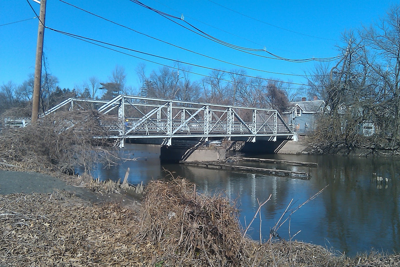
This steel swing bridge replaced the "Washington" bridge
in 1888 and is the oldest span of its type in New Jersey.
Knowing the local terrain meant the difference between survival and surrender for Washington's troops during some of the darkest days of the Revolutionary War. Cornwallis' British and Hessian troops crossed the Hudson in the early hours of November 20, 1776, with the goal of capturing Fort Lee (that's the actual fort, not the town we know today) and the nearly 1000 Continental soldiers garrisoned there. If the troops didn't move fast, they'd be trapped on the narrow peninsula between the Hudson and the Hackensack. And if the British got to New Bridge first, they'd not only be able to capture the Continentals, they'd have a strategic path to penetrate New Jersey and move westward into Pennsylvania without hindrance from the patriots.

Washington was already in the town of Hackensack and met his troops as they neared the crossing. Uncontested by the British, the men made it across the river, marched toward Hackensack and eventually made their way to Newark to recoup. It wasn't until the following day that Cornwallis' troops moved to capture the bridge, which they did successfully despite the efforts of the Continentals' rear guard.

Writer Thomas Paine was an eyewitness to the crossing and related the news in his tract The American Crisis, published about a month later. The decisive battles of Trenton and Princeton were yet to occur, and Paine was pretty much an embedded reporter in current day parlance. His opening words, "These are the times that try mens' souls" were written in New Jersey and still stir passion in the hearts of American patriots today.

Things are a lot more peaceful at New Bridge Landing now. Even though Route 4 and busy Hackensack Avenue aren't far away, you can conjure your own little calm by standing on the bridge and looking south. When we were there, the tide was out and Ivan noted that the mudflats would be great for shorebirds. We didn't see too much avian action but heard quite a bit of spring song in the air. A passive recreation park and greenway on the eastern side of the bridge offers even more opportunity to relax and get back to nature, even with houses across the quiet street.

The Bergen County Historical Society manages the Steuben House but hasn't held regular hours there since the property was flooded during a nor'easter in 2007. Their website has an exhaustive history of the property, along with relevant text from Paine's work.


Sunday, January 8, 2012

A Hidden Trifecta in Raritan

Fresh from our greater white-fronted goose sighting, Ivan and I spotted a small truss bridge and historical marker on the side of the road. Wait! Stop! Turn back! Tiny bridges have always brought interesting stories, and I didn't want to pass this one up.


A Hibernia Mine bridge in Raritan? Isn't that Morris County territory? Had we stumbled on a Hidden New Jersey gem linking two non-contiguous counties? Ivan started reading the marker through his binoculars, but I couldn't help myself. I got out of the car to find out.

Talk about a span with a history! Not only is this an old bridge, it's survived its own obsolescence twice. Originally, it was part of a railroad started in 1863 to move ore from the Hibernia iron mines in Morris County to the Morris Canal and later to the Central Railroad of New Jersey (CRRNJ) at Wharton. The mines were pretty much tapped out by 1916 and closed in 1930, the same year CRRNJ bought the line to serve the area's industries.

By then, though, the bridge had gone on to its second use as a vehicular passageway across a railroad right of way in Hillsborough. It served that purpose for more than 100 years before being dismantled and stored. For the past four years, it's been exclusively a footbridge within the Somerset County Park System, enabling pedestrians to easily cross the Raritan Water Power Canal.

The what canal? When we were in Duke Island Park, we'd wondered if the canal we crossed was simply a portion of the Delaware and Raritan Canal, or maybe a feeder, given the proximity of the Raritan River. I didn't know of any other canal in central New Jersey, so when I read the Hibernia bridge marker, I was stumped. Logic and lessons learned from my many visits to Paterson's Great Falls led me to reason that water had been shunted for industrial purposes, but that's as far as I could figure when we were standing at the bridge. I doubt the Raritan ever supplied the mighty wattage of the falling Passaic River waters, but heck, I could be wrong.

Further research cemented the link: Alexander Hamilton. According to the Raritan Borough website, Hamilton visited the community after the Revolutionary War and thought the river's power could be harnessed to bring industry to the community. Local leaders were less than convinced, but the idea stayed alive and the three-mile long Raritan Water Power Canal was constructed in 1840. Predictably, factories started springing up along the river, taking advantage of cheap power and the proximity of the railroad. That's our link to Passaic County, courtesy of our first Secretary of the Treasury.

Raritan hosted one of the country's largest textile manufacturers, the Raritan Woolen Mills, which supplied the army during the Civil War and World War I. I can't find a direct source confirming the mill used water power, but it was located close to the Raritan, making it likely the Water Power Canal was a factor in its operation. Today, the property is site of a condominium complex. I wonder how many of its residents know their tenuous connection to Alexander Hamilton?


Tuesday, January 3, 2012

No EZPass on the Dingmans Ferry Bridge

I was one of the EZPass holdouts until October, when I got this while using a staffed tollbooth:


Ridiculous as it is not to be able to use paper money on the Parkway, I finally relented and picked up a transponder. I still keep pocket change in the car, though, as there are places in the region where EZPass has yet to extend its tentacled detectors.

Take, for example, the Dingmans Ferry bridge, which links Layton, Sussex County, to Pennsylvania in the Delaware Water Gap. This privately owned river crossing is decidedly low tech, with not even an automated collection basket. One toll collector stands on the line between the two lanes at the Pennsy side, taking tolls from both directions, protected by an awning. The north side of the awning is held up by a little toll house, while the south side is essentially a trellis with signs posted for the next Kiwanis pancake breakfast or Girl Scout fundraiser. It's been this way pretty much since the bridge was constructed, the fourth in a series that runs back to 1835.

Starting a century before that, Andrew Dingman ran a successful ferry service between Layton and Pike County, PA, until one of his descendants opened the first of the bridges. Seemingly, neither that bridge nor the two that succeeded it were constructed to withstand the elements brought by the Delaware and the occasional flood. Today's bridge was built in 1900 of sturdy steel and is closed for inspection for a few days every year to assure its safety. So far, it's held up in four major floods, and one would surmise that with that kind of record, it'll be around for a long time.

Back to the toll taking, I wonder what do they do overnight? Is there an evening toll collector? What kind of traffic does he or she see? And how do they manage in foul weather?

According to the company website, those traveling to church or funerals don't have to pay the toll, but I do wonder, though, if the Dingmans Choice and Delaware Bridge Company people will eventually succumb to EZPass. Perhaps the toll taker will stand in his usual spot and hold a transponder reader to essentially bar-scan people across the bridge.

Thursday, July 14, 2011

Rooting the canal at Griggstown

Wandering around Somerset County gave us the chance to visit one of my favorite, "Wow, this is New Jersey?" destinations, the Delaware and Raritan Canal at Griggstown in Franklin Township. I discovered it a few years ago on one of my dreary-winter-day drives to nowhere, and it seems to be one of those places that's beautiful during every season of the year. For some reason, I never actually consult a map for my trips there. I generally drive by internal GPS, knowing that if I stay on the Canal Road with the canal in sight, I'll eventually get to my destination.

Today, there are enough houses and traffic on the road to make the place feel populated, but back in the days when the canal was the focus, Griggstown must have seemed like one of the few bustling points between Princeton and New Brunswick. Most parts of the canal don't have much in the way of contemporary structures, but here many buildings were constructed to serve its operation. A combination mule drivers' barracks and barn still stands, as well as a lock tender's house and a few other stone structures of indeterminate purpose. There's also a small bridge tender's station at the foot of the wooden Griggstown Causeway crossing the canal and adjacent Millstone River.

Originally a mill town, Griggstown also hosted a copper mine which operated on and off from 1790 to the early 20th century. The community also saw its share of notables during the Revolution, as Washington marched troops through after the Battle of Princeton and Rochambeau led his troops through on the way to Yorktown.

As for us, we just wanted to take a stroll, maybe see a few birds and enjoy a sunny afternoon after tackling the Sourlands. Parking at the lock tender's house, we took to the tow path with the intention of walking to back to the Causeway. We didn't run into too many other walkers, but there were plenty of cyclists and runners capitalizing on the soft, level surface. From the looks of things, a few horses had likely been there, too. The birds were fairly quiet, given that it was already mid-afternoon, but a chickadee or two obliged Ivan with a quick view.

Just east of the Causeway there's a canoe and kayak rental, though we didn't avail ourselves this time around. It didn't seem to be too buggy at all on the water, so it might even be an option for a return trip in August.

Monday, May 2, 2011

Wandering around the natural and abandoned in Sussex County

With spring migration in full force, it was clear that this weekend's jaunt had to include a pretty serious birding component. Wanting to get some distance and history into the equation, we found ourselves headed up State Route 23 and then along back roads to Stokes State Forest and the Delaware Water Gap National Recreation Area. The weather, sunny and seasonably temperate, supported a full day outside in nature. Ivan was looking for some new birds to add to his list for the year, and I wanted my customary dose of abandoned history.

I'm accustomed to getting to the Water Gap from Interstate 80, taking the last exit before Pennsylvania, but I can definitely see the benefits of reaching it from the east, rather than the south. Rather than racing the 18-wheelers, you're gliding through small towns along two-lane roads, small businesses and ultimately, plenty of wooded acreage.

Our first stop was Tillman Ravine, just at the western end of Stokes. As you pull into the small unpaved parking lot and leave your car, you can already hear the water rushing through the ravine bed. A brief hike through the hemlocks will bring you down to the water where it cuts through this seam in the earth, and you can easily traverse the stream a few times by way of sturdy plank bridges. Unfortunately I didn't have the good camera with me, but take my word for it, this is quite a nice place to wander and maybe sit for a spell and meditate with the sound of the current passing you. Doubtless there are a good number of birds in the area, too, but with the gurgling water noises so prevalent, it wasn't easy to hear anyone singing, so we were on our way to our next stop.

Ivan had already told me I'd be surprised how close Tillman was to Walpack Center, and he was absolutely right. Normally I'd reach the small unpopulated village via the NPS road and then drive down Main Street to the one-lane bridge below, but this time I only knew we were approaching because I could see the village church on the hill that overlooks the bridge and the Flat Brook it traverses. I parked the car at the side of the road, across the bridge from several SUVs that belonged to fishermen who'd already waded midstream to their prime trout spots.

Our first stop was a grassy meadow lined with trees and a broad, forested hill in the distance. Ivan was able to spot a few species but for the most part the birds were hiding out, content to sing but not be seen. Contrary to the old bromide about children, birds should be seen and heard. Yes, their tunes were beautiful and a fine accompaniment to a refreshing spring morning, but hey, we'd like to see some feathers, too. The prairie warblers were particularly frustrating -- I enjoyed their song of buzzing notes on a scale, but I really would have liked to have seen some. I did, though, spot what we thought might have been a bald eagle, soaring in the distance.

Now, just a few words on Walpack Center, which appears, to the unknowing visitor, to be a total ghost town, complete with church, schoolhouse, post office and gas pump. This was, at one point, one of New Jersey's hidden mountain towns, but became desolate when the federal government started on plans to build the Tocks Island Dam across the Delaware River in the early 1960s. The project, designed to manage downstream flooding, generate hydroelectric power, and create a massive recreational lake, required thousands of acres of land that had been occupied by dozens of farming families, many for generations. Depending on which reports you read, the government either declared eminent domain or strong-armed the residents off their property, leaving virtual ghost towns to be torn down before the river was dammed and the area was flooded. Ultimately, a combination of factors stopped the project, which was deemed as both geologically unwise and unfair to those who had lived there. The government land was transferred to the National Park Service in 1965, creating the Delaware Water Gap National Recreation Area.

Today, Walpack Center is a clutch of whitewashed buildings, including one that's used as a rarely-opened museum, and another that's occupied by a Park Service employee. As we found out, it's also a luckier spot for birds than the meadow we'd been checking out. All on my own, I spied a woodpecker bopping around in the upper branches of a tree, just before he popped into a nesthole. We also saw a nice collection of warblers in a wooded area, while standing on a stairway outside the village church. Things were looking up.

Satisfied we'd probably seen what the village had to offer, we started wandering south on the Park Service road to another spot next to a barn. Ivan had seen cerulean warblers there on a previous visit and while there was no sign of them when we were there, the songs in the air promised some really cool sightings and totally new birds for my life list. Just a few minutes after we'd gotten there, an orchard oriole stopped by on the branch of a tree just a few feet away. Very cool, but Ivan was on the lookout for an even more striking bird we could hear high up in the next tree. It was just a matter of finding it without spooking it.

And... then, there it was, perched among the fresh young leaves of the tree: a scarlet tanager! You could see him, plain as day, bright red body with black wings. (Boy, do I wish I had the camera and the right lens.) What a treat! Though he was somewhat obscured by the yellow leaves, he hung out for a good while, allowing us to get an extended view of him.

So, with those successes fresh, we drove back down Old Mine Road, checking one other spot (no luck) and keeping the windows open to listen for other bird songs on the way. There were likely other birds at other locations, but our stomachs were rumbling and we needed food pronto. We were on the way to our next stop.

Thursday, March 24, 2011

Visiting the D&R canal at Bull's Island

Alas, Sunday was to be the day of narrow bridges and muddy shoes. After a brief lunch stop in Lambertville, we continued up State Route 29 to Bull's Island, part of the Delaware and Raritan Canal State Park in Stockton.

Essentially connecting the two rivers whose names it bears, the D&R Canal was built in the early 1830s to bring Pennsylvania coal to New York, and manufactured goods back in the opposite direction. And while it was quite busy through the mid part of the 1800's, it, like most every other canal in America eventually lost out to the railroads. Now it's one of New Jersey's most used and picturesque state parks, offering level pathways for cycling, hiking, running and horseback riding. Its 70 mile route is also home to several of the original lock and bridge tender houses, and while they're generally not open for visitation, they add a nice touch of authenticity.

From the Pennsy side.
Our visit, of course, was dedicated primarily to birding, but before we focused on that, Ivan had a nice little treat to share with me: yet another narrow bridge. We'd driven across one to get beyond the feeder canal to the island, but that wasn't remarkable at all when compared to the footbridge over the rushing Delaware. While it was only wide enough to allow maybe three people walking abreast, the bridge was plenty sturdy, with a concrete deck and firm anchors below. It was getting a lot of use while we were there, too: strollers, hikers and cyclists seemed to come out of nowhere to enjoy the trip across.

Later, I read that the bridge isn't the first to cross the Delaware at that point. The original was built in 1835 as a covered structure, but part of it was swept away by flood in 1903 and then replaced by a steel span; the whole thing was taken out of use in 1946. The present footbridge was built in 1949 to allow folks from the Pennsylvania side to get to a now-defunct passenger train on the Jersey side.

It seems that now, the only purpose for the bridge is to bring people between Bull's Island and the unbearably cute hamlet of Lumberville, Pennsylvania, in scenic Bucks County. Of course, there's an adorable inn along the river, with a general store/gourmet deli right across the street. It seems to be a good place to have one of those weekends that feels about a week long.

Once back across the river, we got the birding going. Given all of the recent rains, it wasn't surprising that the towpath along the canal had that special 'give' of mushy ground. I wouldn't say it was muddy; it was more like the consistency of undercooked brownies (mmmmm.... brownies!). Note to self: check boot treads before getting back into the car.

We weren't far down the path when Ivan spotted what, to me, was a fairly remarkable sight: a pileated woodpecker. For the uninitiated, it's best described as a big honkin' woodpecker (not that it honks -- you know what I mean). The photo to the right doesn't quite do it justice -- it's a little blurry and you can't really get a sense of size, but take my word for it when I say this is probably twice the size of the average hairy woodpecker drilling away at a tree in your backyard. We were treated to a few minutes of watching this guy checking out a few limbs, plus the spectacle of him flying away to a distant other tree. That just about made my day. It certainly made all of the brownie-tromping worthwhile.

Farther along, we navigated through and around a nest of fallen limbs to find some other feathered fauna, including a happy little song sparrow just singing away. Spring is the best, isn't it? So much cheerful noise all around.

Eventually, we decided we had enough and made our way back to Route 29 and who knows where. Trusting the Garmin to get us home, we realized there were a few other places we might find along the way. What next?

Wednesday, March 23, 2011

Washington's Crossing: What if the Father of our Country had had E-ZPass?

After checking out Riverview Cemetery, we made a quick pit stop at the Trenton Visitors Center in the old Masonic Lodge House located on Barrack Street, not far from the State House and the War Memorial building. The small fieldstone building was erected in 1793 and has since been replaced by a grander structure just up the street, but according to the young woman staffing the visitors center, the Masons still occasionally hold meetings there. Interestingly, the first grandmaster Mason in the New World was a Trenton native, Daniel Coxe.

A short history of the Battles of Trenton and Princeton is prominently displayed in the main room, complete with strategic troop movement maps and an outline of events. Known to Revolutionary War buffs as the ten crucial days, this period in the winter of 1776-77 started with Washington's famous crossing of the Delaware River on Christmas night, continued with valiant fighting in Trenton and ended with a decisive victory at Princeton ten days later. These battles were particularly important to the cause, as Washington's troops were dispirited from several previous losses, and weren't re-upping after their 30-day enlistments came to a close.  Winning in New Jersey gave the Continental Army a much needed shot in the arm and the encouragement to continue fighting for the cause of freedom.

The whole venture started with the transport of 2400 troops, sizeable quantities of artillery and horses across the river from Pennsylvania to a site about 10 miles north of Trenton. Both states maintain parks at the crossing, and while I'd been to the New Jersey side, I hadn't ventured to its Pennsy counterpart. In my mind, it doesn't matter so much where Washington left from, as much as it does where he landed. But, given it's a site so closely related to New Jersey history, I agreed with Ivan that it warranted a visit.

Unlike the larger toll bridges farther downstream, the span across the river to Washington's Crossing, PA is barely wide enough to accommodate two cars passing each other. Not surprising, since it was built sometime in the 1830s. As we crossed the Delaware, I resisted the urge to stick my head out of the sunroof and gaze forward determinedly as Washington did in the famous Leutze painting. It was enough of a challenge to nudge past oncoming cars without losing the side-view mirrors.

The bridge deposited us in a tidy little village of colonial vintage, aside from the construction office-type trailers being used as temporary quarters for the visitors' center. Unfortunately, the boat sheds were also closed; Ivan told me that the replica flat-bottom Durham boats were huge and deserved a good look, so that will have to be done on a future visit.

Combining history with a little birding, we took a stroll farther on to an open grove where Washington's troops apparently massed before the crossing. Here's what we found there:


I'll leave you to mull on that one, but I'll tell you that my mom always advised making a quick visit before heading out on a trip. Perhaps Washington did, too. We can safely assume he wasn't about to turn the boat around to accommodate someone's bathroom needs.

The birding was variable; the presence of bluebird boxes led us to try to find a few, without luck. We did spy a black vulture across a pond, plus some other random songbirds and such. And I was able to get a pretty neat shot of a couple of mallards taking a rest (plus a bonus turtle to the right).


If you happen to be in the area at Christmas, it's well worth a visit for the reenactment of the crossing. You can even participate if you register in advance and wear a period costume. Be warned, though: for several years, the troops took the bridge because the river wasn't high enough to support the passage of loaded boats. It makes one even more thankful that the weather was what it was when Washington brilliantly planned to surprise the Hessians at Trenton.