Thursday, April 5, 2012

Checking out both sides of the tracks in Carpentersville

Yesterday I returned to the site of one of our more disappointing winter adventures in Pohatcong Township, hoping for better luck.

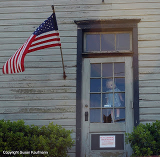
See, we'd gone there the day after one of this winter's rare snows, only to find we were barred from the area's chief birding spot because the road wasn't plowed properly. When we tried to find an alternate route, we ended up in the small village of Carpentersville, which appeared to be just a few houses and a couple of public buildings. I didn't think much of it until I looked up at the door to the one-room schoolhouse and saw a large doll just inside, hanging by its neck. That, plus the inordinately large number of POSTED and NO TRESPASSING signs got me thinking that perhaps it wasn't the friendliest place in the world. I took no pictures, though I was really tempted to.
Fast forward to yesterday. The weather was much nicer and I'd spent a total of 10 minutes at Motor Vehicle getting the biannual car inspection, so a road trip was in order. Maybe I could figure out the whole Carpentersville thing.

An hour and a few side trips later, I discovered the doll essentially hasn't moved since January, though there's now an unfriendly sign on the door, banning trespassing and gunning. (Gunning? You mean, using a gun, or revving an engine?). Check it out:

spooky hanging doll

Well, I was there, so may as well do a little driving around. I hit a big "Do Not Enter" area farther down the road the hanging doll was on, so I made a right turn onto River Road. I found myself driving alongside a railroad track mounted on a berm. Several hundred yards down, the road split, the right side going to a gravel company and the left crossing the tracks and skirting toward the river. I went left.

For some crazy reason, it didn't occur to me that it was the Delaware I was seeing. I guess I'd lost my bearings once I left Route 78 and didn't realize how far west I'd gone. At that point, the river isn't anywhere near as wide as it is at the Water Gap, and the houses along the banks were pretty modest.

The train tracks still had me wondering, so I turned the car around and retraced my path in the hopes of discovering something, perhaps an old station. On a previous trip to Phillipsburg, we found a depot for the Belvidere and Delaware Railroad, which now offers occasional leisure rides along the river. Perhaps this was part of it?

River Road dutifully hugged the tracks, much as a tow path accompanies an old canal. Once I got past the little enclave where the hanging doll road intersects River Road, the pavement narrowed and fewer homes lined the way. Soon, the left side of the road was defined by craggy rock about 10 or 20 feet high, and the tracks to my right were looking less and less used. I passed a crew of two workers who appeared to be using picks to clear growth from around the tracks, but then... nothing. At points, the tracks were laid dangerously close to the river; I couldn't help but think that if they were used with any regularity, their owner would have shored them up more firmly. In fact, I have to believe that there's been significant erosion since they were first laid. Who'd take the chance a well-laden freight would tumble into the river?

Not to worry: the road and tracks eventually intersected again, giving the rail route a comfortable distance from the banks. A little farther down and to my left, I saw a few old stone structures built into the hillside, looking very much like furnaces. Research later told me that locally quarried lime was processed here and then shipped out for use as fertilizer and an essential ingredient of cement. To me, however, they looked a lot more medieval, especially the less well-preserved ones. Perhaps someone was inside with a vat of boiling oil? Who knows. It seems to fit well with the slightly unfriendly vibe I felt back in town.


Monday, April 2, 2012

Cheap gas... mall shopping... and a duel?

New Yorkers flock to current day New Jersey for cheap gasoline and tax-free clothing shopping, but in the early days of the United States, they had another reason for crossing the river: settling disputes. At the time, dueling was a socially accepted means of resolving a grudge, but laws against the practice in New York were severe and strictly enforced. New Jersey, however, was a bit less meticulous about stopping duels and punishing the participants. Even New York Governor DeWitt Clinton is said to have taken advantage of the site to settle a disagreement.

Hamilton Burr duel siteThe cliffs of Weehawken were a favored spot for duelers -- they were close to the river for quick arrival and exit, and the surrounding brush and trees offered some cover. Today the bluff above the then-popular site is marked to denote the tragic 1804 duel that took the life of Treasury Secretary Alexander Hamilton while plunging Vice President Aaron Burr into infamy. A bust of Hamilton commemorates the event not far from where it occurred, accompanied by a stone on which his head was allegedly laid after he was mortally wounded.

What few people know is that Hamilton's son Phillip died by similar circumstances, not far away, three years earlier. Viewed by his father to be the family's "brightest hope," the 20-year-old was being groomed as a successor to continue on the family work in government and politics. Thus, it wasn't surprising that Phillip took umbrage at insults he perceived in an 1801 Independence Day speech by a young Republican lawyer named George Eaker. Words were exchanged, Eaker called the young Hamilton a rascal -- fighting words in that day. A duel was arranged shortly after.

According to the recent biography written by Ron Chernow, the elder Hamilton was torn when he heard of the impending clash. While having moral objections to dueling, he still felt it important to defend one's honor and integrity when insulted. He counseled Phillip to either hold fire or shoot in a direction away from Eaker. That way, if he were shot by his opponent, it would be considered murder. It was a very similar strategy to the one Hamilton would use in his own duel with Burr three years later.

Sadly for all involved, the strategy worked about as well for Phillip as it would for his father. Meeting his opponent at Paulus Hook in Jersey City, he held fire and calmly took the shot Eaker discharged. He died the following morning, attended by his grieving parents. You'd think the experience would have served as a lesson for Hamilton in his dealings with Burr, but his inability to see the futility of dueling would cost him his life, as well.


Saturday, March 31, 2012

The Lost City of Gold in Weehawken: Eldorado Amusement Park

If you're of a certain age, you might remember Palisades Amusement Park, the entertainment complex that once stood high above the shores of the Hudson River in Cliffside Park and Fort Lee. Between the rides, the pool and the entertainment, it was a big draw for families in the New York metropolitan area until it closed in 1971. Real estate values, it seems, trumped the need for nearby fun, and besides, the host towns appear to have grown weary of the crowds overtaking the park. Municipal officials had hastened the closure by rezoning the property for high-density housing.

Palisades, however, wasn't the first big attraction on the Hudson Cliffs. The Eldorado Amusement Park in Weehawken was a haven for pleasure-seeking visitors starting in 1891, offering a more refined experience. I stumbled upon the story while wandering Boulevard East in search of the site of the Alexander Hamilton-Aaron Burr duel.

Eldorado spanned from the cliffs of the Palisades west to current day Highwood Avenue, bordered by Liberty Place on the North and Duer Place on the South. It lacked the rollercoasters and other rides of more pedestrian parks of the day, preferring to offer more impressive attractions, if the superlative reports of the day are to be believed. Civic leaders, incorporated as the Palisades Amusement and Exhibition Company, built a Moorish themed casino, amphitheater and cliffside castle surrounded by beautifully landscaped gardens. Hungarian impresario Bolossy Kiralfy staged massive shows with casts as large as 1000 performers in the huge music pavilion. A 30 foot fountain on site was said to be the tallest and most expensive structure of its kind in America.

New Yorkers had long been ferrying across the river to flee the hot city summers, and they came to Eldorado in droves. Then, as today, visitors on the shores of the Hudson are greeted by the sight of the massive Palisades, and roads at the time weren't as helpful as they are now in making one's way to the top. An ingenious elevator and train system brought them from ferry slips at the river bank to the park 150 feet above. The marvel was featured in an 1891 issue of Scientific American, sounding very much like a steroid-fed version of the trams we see at amusement parks today.

Information on the park is a bit sketchy, but it seems that a large fire at the casino building in 1898 was the beginning of the end for the Eldorado. Its owners demolished the remaining buildings and sold the property as lots for an exclusive residential subdivision. Proximity to Manhattan was a huge selling point, but fortunately high-rises weren't yet in vogue. Though packed somewhat tightly by suburban standards, the houses that were built on the lots have plenty of character.

Today, the only signs of Eldorado in Weehawken are a historic marker on Boulevard East, and an Eldorado Place. Much like the lost city of gold, it's as if it never existed.

Wednesday, March 28, 2012

How now, Brown..... University?

Last week's County Road 518 jaunt brought me through Hopewell, a community justifiably proud of its roots. Not only was the town the home of Declaration of Independence signer John Hart, it boasts a lovely old Baptist meeting house and a number of other colonial-era buildings. I wasn't surprised to find a few historical markers in town, but I was thrown for a loop when I read the sign in front of an unadorned white colonial house. Apparently the building had once served as a Baptist parsonage and a school called the Hopewell Academy, from which today's Brown University developed.

So, wait: Brown, the Ivy League school in Providence, Rhode Island, actually started here in New Jersey? Well, it depends on what you mean by 'started.' The university's own website is a bit fuzzy on the school's origin, but other sources state that Brown, like most, if not all of the nine colonial colleges, was conceived by a Protestant sect to foster learning and to train men for the ministry. In this case, it was the Baptist church in Philadelphia that planted the seed, and Reverend James Manning was sent to lead the formation of the school.

Manning himself was a Jerseyman, born in Elizabethtown, raised in Piscataway and educated at the Presbyterian-run College of New Jersey. Before attending the precursor to Princeton University, he prepared for his religious studies at the Hopewell Academy, the first Baptist educational institution of its kind in America.

If the impetus for the founding of Brown came from Hopewell and Philadelphia, then why is the school located in Rhode Island? The answer is simple: the colony then known as Rhode Island and the Providence Plantations was home to the first Baptist church in America. The training ground for ministers would be located at the cradle of the faith. Congregationalist ministers were working to establish a school there, as well, so the two groups joined forces to develop what's known as Brown University.

Manning was the first president of the college, also serving as minister of the mother Baptist church in Rhode Island. Later, he was appointed to the Seventh Congress of the Confederation of States, the nation's legislative body before the ratification of the U.S. Constitution. Not bad for a Jersey guy, huh?


Sunday, March 25, 2012

Where Edison concentrated: iron ore processing at Ogdensburg

A little over a year ago, we made a trip out to Thomas Edison's concrete mile on Route 57 in Stewartsville/New Village, the site of his famed Portland cement factory. What I didn't mention in that account was the earlier use of the equipment that ground stone into fine enough particles to make a durable concrete.

You see, the Wizard of Menlo Park didn't originally set out to make concrete. He was looking to capitalize on the high iron content of the northwestern reaches of New Jersey, to supply concentrated iron ore bricks manufactured from the raw material of Sussex Mountain. And to do it, he built the first Edison, New Jersey: a veritable city of workers and innovative rock crushing machinery that used magnetic force to separate iron from pulverized stone. While mines in western Morris County and beyond were starting to peter out of useful material, he somehow thought that his experience would be different. No matter what, you've got to give the guy credit for optimism.

Finding the Edison mining property wasn't all that easy for me -- this is a trip I took before Ivan and I met, so I didn't have the benefit of his knowledge of the area. After some internet research, I discovered that my target was just off Sussex County Road 620 in Ogdensburg. More specifically, it's on Edison Road. For some reason, the Garmin people hadn't included 620 on their GPS maps, so I was left to do a little automobile bushwacking once I got into the Sussex area.

I arrived to find a stone and brass marker erected by Sussex County not too long ago, and a sign with topographic mapping of several trails that ramble through the woods. Noticing a New Jersey Audubon logo on the topo sign, I realized that I'd come upon one of the organization's unstaffed areas, and that if I'd bothered to look at my Audubon trails guide, I'd have known exactly where to go.

If you check the area out for yourself, be sure to stop at the county marker and check out the photos embedded in it. They show an environment that differs substantially from the woods and open fields currently on the property. More than 500 men and several huge pieces of processing machinery were working furiously during Edison's time there, and there's little to show for it now. Yes, as you walk around, you'll find the remnants of rustic looking stone walls, and a fair number of steel reinforcing rods poking up from the ground, but besides that, there's little to indicate the industry that existed there from 1891 to 1900. Still, though, random rocks on the ground show the telltale reddish-brown shade of oxidized iron. And fittingly, the area is now traversed by a set of high-voltage transmission lines.

Edison spent much of his time at Ogdensburg during the eleven years his iron ore business operated, ultimately spending about $2 million of his personal wealth on the unsuccessful venture. Characteristically unaffected by the cost of yet another experiment that didn't work out, he said, "Well, it's all gone, but we had a hell of a good time spending it!"

Where does the cement come in? Like any great inventor and entrepreneur, Edison studied the failed venture to determine lessons learned. He noted that the crushing machinery was especially good at manufacturing finely-ground material that could be used in high-quality cement. The machinery was moved about 45 miles southwest to New Village, and in 1903, a new business was born: Edison Portland Cement. From roads and houses to Yankee Stadium, this durable material showed up all over the place as Edison strived to find markets for the product. Once again, he'd managed to make some pretty tasty lemonade from the lemons he'd been served.

Thursday, March 22, 2012

Straddling the Jerseys on Province Line Road

Drive around Mercer County near Princeton, and there's a chance you'll come across Province Line Road. Since you'd be comfortably inland from the state boundaries of the Delaware River and the Atlantic Ocean, you'd be excused for wondering how that name came about. The road certainly isn't marking any contemporary boundary, so what's the deal?

I discovered the cause during a recent wandering on County Route 518. Transfixed by the pastoral scenery, I saw the street sign for Province Line and took a turn to see where it would take me. Rounding the corner, I noticed this on my side of the intersection:


To save your eyes a bit of strain, I'll give you the synopsis. When the English took control of the New York/New Jersey area in 1664, the Duke of York gave New Jersey to two lords, Carteret and Berkeley, who probably never even set foot in the New World. The two then designated local representatives to sell portions of their shares to people who actually lived here, who became known as proprietors. (I shared a little of this in an entry about our visit to Perth Amboy last year.)

Look at the map on the plaque, and you'll see a dotted line above Three Bridges. That's where the fun starts. Naturally, when land is conveyed to new owners, boundaries are decided upon, but when it came to East and West Jersey, the process wasn't as simple as a brief discussion over a map. The Duke had divided the east and west provinces with a diagonal line reaching from Little Egg Harbor on the Atlantic to the spot where New Jersey and New York meet on the Delaware River. Sounds easy, right? It would have been, but that border wasn't officially settled until 1769. You can see the problem.

East-west lines were drawn in 1687 and 1719, but the one that stuck was plotted in 1743 by John Lawrence, now marked by Province Line Road near the plaque I found. Nonetheless, the proprietors of continued to squabble over the boundary for another 140 years. These guys really took their jobs seriously, even after their work ceased to have much relevance from a property-deeding perspective. They could learn a lesson from Steve Chernoski, the documentarian who's tackled the mystery of the line between North and South Jersey. Drive around a bit, ask the locals which side they identify with more, and decide by acclaim.

I read a few years ago that a group of surveyors were using GPS instruments to determine the straightness of Lawrence's line. If they drove the same stretch of Province Line Road that I did, they'd be pretty impressed. Check out how straight it is:


I wish I could report that the full length of the road is as pin-straight and travels clear to Little Egg Harbor, but it's not and it doesn't. About a mile away from where I took this photo, I ran into a dead end and had to resort to an intersecting street. Looking at the map when I got home, I discovered the road makes some twists and turns before terminating near a shopping mall.

Tuesday, March 20, 2012

Sue and Ivan versus the Volcano

The folks at Lusscroft Farm have been tapping the property's maple trees in preparation for a maple sugaring event held on St. Patrick's Day weekend. I only became aware of it a day or two beforehand, and I insisted that we had to make a return visit to see whether New Jersey maple syrup is better than the Vermont variety.

We'd just stumbled on the place the first time we visited, so this time I made sure we had the address plugged into the GPS. Rather than bringing us to the front gate, it took us around the side, past a surprising street sign:

Sorry for the blurriness of the photo. I guess I was so excited
that my hand was shaking, plus I was using a phone camera.
A volcano? This was a new one on me. The last time I ran into a sign like this on the road, I was in Hawaii, where you're driving on literal volcanoes all the time. New Jersey, it need not be said, is not exactly known for its volcanic activity. Then again, the hill we were driving on did seem kind of different from the others we'd traversed in Sussex County.

A little bit of research revealed a little bit of information. Rutan Hill, as it's called, is, indeed, a 440 million year-old extinct volcano. Not only is it the only one in New Jersey, it's one of the two spots in the state where one can see the natural occurrence of nepheline syenite, a very rare igneous rock with origins in magma. The volcanic action also essentially baked the surrounding sedimentary rock, which we saw as we hiked around Lusscroft. A lot of the stones seemed a little grayer than what you usually see, and maybe a little more crumbly, but that might have just been my perspective.

Given the title of this entry, you're probably wondering if we went to the peak of the volcano to make a symbolic sacrifice. Well, in true Jersey fashion, the road was marked "PRIVATE -- DO NOT ENTER," and while we surmised that residents had put the sign up illegally to deter curiosity seekers, we didn't want to take any chances. And sadly, builders had already made a sacrifice we'd never dream of: they covered the apex of the hill with a house. Those attempting to get a view of a geologic wonder are left trying to imagine the volcano untouched by the hand of man.

The maple syrup quest was both interesting and disappointing. They'd sold out of syrup by the time we got there, but we got a little taste along with an education on the maple syrup process. For one thing, we learned that a grouping of tapped maple trees is called a sugarbush. And the sap gathering process isn't what we expected. Instead of gallon buckets hanging from individual taps, they use a vacuum-sealed system of flexible tubing that collects the sap and delivers it, by gravity, to a central receptacle downhill. Pretty cool!

I guess you could say that for the day, the state-by-state comparisons were a mixed bag. On volcanoes, New Jersey definitely pales in comparison to Hawaii, but to this taste tester, our maple syrup is definitely on a par with Vermont's!